OUR FLYING SITES
If you are visiting the area on holiday and wish to fly, PLEASE contact a member of the committee to get permission to fly one of the privately owned sites. They will be able to tell you the opening and closing times of the sites and any special conditions that may apply.
POWER SITE (Private)
Flying times for I/C aircraft are as follows:
MONDAY - SATURDAY...........9.00am to ½ hour before dusk
SUNDAY & BANK HOLIDAYS...10.00am to ½ hour before dusk
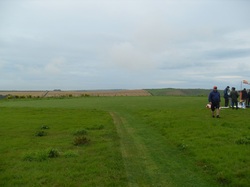
The club uses a PRIVATE flying site, 2 miles to the west of Winterbourne Abbas.
This has a rolled and close mown grass runway that measures 60 metres in diameter, a car parking area, it's own entrance from a concrete farm track, and is available 7 days a week.
Flying times for I/C aircraft are as follows:
MONDAY - SATURDAY...........9.00am to ½ hour before dusk
SUNDAY & BANK HOLIDAYS...10.00am to ½ hour before dusk
The club uses a PRIVATE flying site, 2 miles to the west of Winterbourne Abbas.
This has a rolled and close mown grass runway that measures 60 metres in diameter, a car parking area, it's own entrance from a concrete farm track, and is available 7 days a week.
SLOPE SOARING
The sites fall into two categories with permission to fly Private sites and PUBLIC SITES.
PRIVATE SITE: LITTON CHENEY
A natural bowl that is capable of flying with wind directions from SW through South to SE. Please do not use Channels 72 and 79 at this site as they are in semi-permanent use on the other side of the road.
A natural bowl that is capable of flying with wind directions from SW through South to SE. Please do not use Channels 72 and 79 at this site as they are in semi-permanent use on the other side of the road.
PUBLIC SITE: RINGSTEAD - National Trust site for southerly wind (Many other users including hang gliders)
PUBLIC SITE: MAIDEN CASTLE- North slope/north east facing slope.
PUBLIC SITE: WHITE HORSE - South facing slope. Also used by hang gliders.
